
Location: Granite Tors Rd, Tennent Creek ACT 2620
Country: Ngunnawal
LGA: Australian Capital Territory
Region: Southern Tablelands
Website: www.parks.act.gov.au/find-a-nature-park/namadgi-national-park
Map: Below
Extracts from ACT Heritage Council: Background Information, June 2016
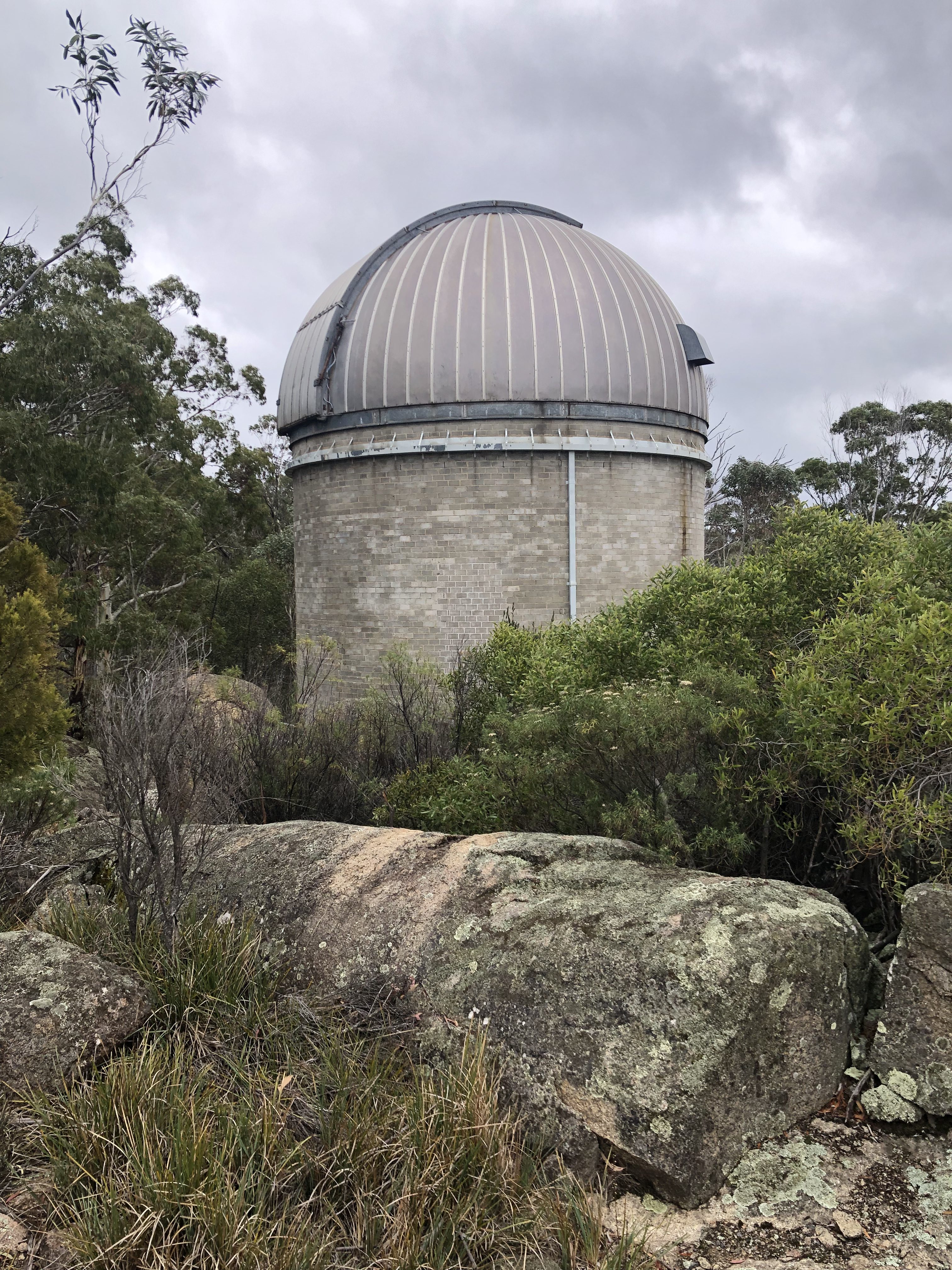
The Orroral Geodetic Observatory was built in 1974 as part of an agreement between the United States (US) and Australia called the Hornig treaty, a cooperation in science and technology.
The Division of National Mapping (NATMAP) and the National Aeronautics and Space Administration (NASA) were the signatories (Geoscience Australia 2015a). In the late 1980s NATMAP became the Australian Surveying and Land Information Group (AUSLIG), which subsequently became Geoscience Australia.
Hornig saw the beginning of Australia’s Lunar and Satellite Laser Ranging (SLR) Program. Using a laser, SLR measures the distance to Earth orbiting satellites which revolve around the Earth’s centre of mass. Laser is an acronym for Light Amplification by Stimulated Emission of Radiation. It is a device for producing a narrow beam of light of a single frequency or colour and constant relative phase (Clark 2012: 92).
SLR is important in the study of geodesy. Geodesy is the science of accurately measuring and understanding three fundamental properties of the Earth: its geometric shape, its orientation in space, and its gravity field — as well as the
changes of these properties with time. Geodesists must accurately define the coordinates of points on the surface of the Earth in a consistent manner which is aided by SLR (NOAA 2015). SLR works when measurements are made by transmitting pulsed laser beams from Earth ground stations to the satellites. The laser beams then return to Earth after hitting the reflecting surfaces; the travel times are precisely measured, permitting ground stations in different parts of the Earth to measure their separations to better than one inch in thousands of miles (NASA 2015).Data from a global network of SLR stations is used to estimate the orbital parameters of satellites which revolve around the Earth’s centre of mass, providing permanent reference points so that the Earth’s progress can be tracked relative to the satellite, as opposed to traditional satellite tracking where the satellite’s progress is tracked relative to the Earth (Earth Observation Portal 2015). Therefore the position of the Earth’s geocentre (the origin of the Global Geodetic Reference Frame, see Endnote 1 on page 7) can be monitored through time.
SLR has become an important geodetic instrument used for the establishment of an accurate global geodetic infrastructure and Earth monitoring science (Geoscience Australia 2015a). As a contributor to the SLR network, the Orroral Geodetic Facility was part of a system of measurement which for the
first time was able to measure the motion of the tectonic plates, providing an explicit and independent verification of the theory of plate tectonics, a theory which today still underpins all geological science (J. Dawson personal communication 14 August 2015).The Orroral Geodetic Observatory took its first observations of the LAGEOS satellite in 1984 (Geoscience Australia 2015a). LAGEOS (Laser Geodynamic Satellite) was the first satellite dedicated wholly to SLR, able to determine position
points on Earth due to highly stable orbits (Earth Observation Portal 2015). It was a US satellite constructed using a brass core covered with an aluminium shell, holding 426 corner-cube reflectors resembling shiny golf-balls, from which SLR stations took readings (Clarke 2012: 92).There are numerous SLR satellites orbiting Earth, and the LAGEOS mission is still operational, providing orbital benchmarks for geodynamical studies of the Earth. The high mass-to-area ratio and the precise, stable (attitudeindependent) geometry of the LAGEOS spacecrafts, together with the extremely regular orbits, make these satellites the most precise position references available (NOAA 2015).
… Broadly, SLR has an origin in Lunar Laser Ranging (LLR), where laser pulses were fired to the moon and were bounced back by retroreflectors placed on the lunar surface by astronauts of the Apollo program. Measurement of the pulses
enabled calculations on continental drift. It took about 2.5 seconds for the laser pulses to cross the 385,000km between Earth and the Moon, and back again. LLR proved problematic since the Moon travels away from the Earth by
around 8cm per year, therefore, the focus of laser ranging moved to SLR, as satellites could provide orbiting benchmarks (J. Manning personal communication 31 July 2015; 2015; NOAA 2015).… In addition to SLR, eventually the Orroral Geodetic Observatory also hosted: 1.) A geodetic survey pillar. 2.) Global Positioning System (GPS) receivers. 3.) Four caesium atomic clocks. 4.) A Doppler Orbitography and Radiopositioning Integrated by Satellite (DORIS) receiver (Barrow 1999).
… The Orroral Geodetic Observatory’s functions were transferred to Mt Stromlo in the late 1990s, its internal components, such as the laser and telescope, had been removed by December 1999, although the dome-shaped shell was left standing.
At its time of operation Orroral Geodetic Observatory was the only geodetic station in Australia capable of the diverse functions outlined above. This made it Australia’s fundamental geodetic facility, hosting a range of instrumentation
developed by different countries. Having the SLR, survey marker, DORIS, GPS and atomic clocks collocated at the facility enabled measurements from disparate systems and satellites to be linked for mutual benefit and science outcomes.Data collected from the facility is still in use by the international science community. As new data is observed by upgraded observatories, the information collected by the Orroral Geodetic Facility is used by agencies such as Geoscience Australia and the Officer of the Surveyor General (ACT Government) to contribute to the ongoing refinement of the global coordinate system which underpins present day understanding of tectonic plate motion, sealevel change, crustal deformation and Earth rotation (J. Dawson personal communication 14 August 2015).
The facility gathered data contributing to national and international research that may inform future strategies managing natural phenomena and disasters. Accurate study in these fields requires measurement of temporal changes on Earth in very small magnitudes (at the millimetre level). As such, the necessary observations must be spread over decades. The Orroral Geodetic Observatory received this data, and the information collected from decades of recording is continuously used in geodetic studies that inform strategies to manage climate change and
earthquakes (Barrow 1999; J. Dawson personal communication 14 August 2015).In summary, data from the facility contributed to a global baseline dataset from which current changes to the surface of the Earth (caused by factors such as climate change) can be related (J. Dawson personal communication 5 January 2016).


Captions: all photos by bushwalker Sally Stephens, Canberra. June 2025.
This post is a stub waiting to be extended. If you have expert knowledge or lived experience of this site and would like to write about it, please read our authors’ Guidelines and Contact us.
Post published 4 July 2025.
Permalink: https://inlandastrotrail.com/orroral-geodetic-observatory/